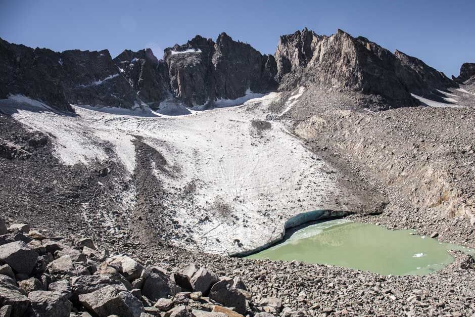
There are two significant glaciers in the 209’s backyard.
Both can be found in Yosemite National Park.
They are among 497 glaciers — as listed by the United States Geological Survey in 2006 — that can be found in California. The USGS also lists 788 smaller ice bodies that don’t meet the criteria to be classified as glaciers. The glaciers as defined by the USGS 14 years ago covered some 25 square miles of California and have since shrunk in size. The ice bodies surveyed in 2006 covered roughly 5 square miles.
Most experts today put the number of glaciers in the Sierra at less than 100.
Glaciers are large, thick masses of ice formed with accumulative snowfall over the years that have the ability to flow.
The largest in Yosemite is the Lyell Glacier found on the western slope of Mt. Lyell that at 13,114 feet is the highest peak both in the park and Tuolumne County. Right next door is the Maclure Glacier that has been moving at a steady inch a year.
During the Ice Age most of the Sierra was covered with glaciers. To give an idea of their size, the Tuolumne Glacier that helped carve the route of the Tuolumne River at one point was 67 miles long. The Lyell and Maclure glaciers were formed during the Little Ice Age that took place between the 16th and 19th centuries. It has been steadily retreating since the 1800s. It has retreated around 70 percent since 1883. A 2013 study contends it is no longer a glacier and should be reclassified as essentially a large ice patch as it has stopped moving. Yosemite National Park information sheets, however, still note that it is a glacier.
It takes a bit of effort to reach the two glaciers. It is a 13 plus mile one-way hike from Highway 120 out of Tuolumne Meadows.
A much more attainable glacier that is less than a three hour drive is Dana Glacier just outside Yosemite Park via Highway 120 with a trailhead that starts on the southern side of Tioga Lake.
It is considered a strenuous hike covering six miles going from 9,648 feet to 11,302 feet. The “easiest” route includes Class I and Class 2 portions to reach the base but reports in recent years of a rockslide along the shores of the last lake has turned it into a Class 3 hike at that point.
Class 3, in case you are wondering, means scrambling with increased exposure. Freely translated that means hand holds with rope are advised for beginners although it is not usually required. Falls on Class 3 routes could easily be fatal.
I have yet to tackle the hike but based on photos I’ve seen and how it’s been described I’m planning to do it this summer but only to the point where it gets treacherous. From photos others have shared to get to that point would be well worth the effort given the view and stark solitude as you are above the tree line.
The one glacier I have hiked to — just to the top of the ridge of a rock and scree field overlooking the moraine that is a deposit of boulders, rocks and other debris pushed downhill by the force of moving ice — is the Palisades Glacier west of Big Pine. It’s the largest glacier in the Sierra in the shadow of a series of 14,000-plus foot peaks.
Why I didn’t go down to the aqua blue lake at the base of the glacier had to do with three things. I had scheduled it after a day hike the previous day of some 8 miles out of June Lake. I assumed because I had been on the trail before to Sam Mack Meadow at 11,100 feet and the time I did that in, that I could tackle the entire 17.1 mile hike with a 4,704-foot gain in one day given I’ve made the 22-mile round trip up to Mt. Whitney’s 14,505-foot summit that had a gain of 6,100 feet as a day hike three different times. I overestimated my feet’s ability to recover less than 12 hours after completing a moderately strenuous hike. The real killer was misjudging the best route up the scree field.
Other hikers I encountered that were returning from the glacier suggested a more western route than I ended up taking. Long story short I found myself on an unstable boulder and rock field at a grade that was getting deep into Class 3 territory. I was basically close to a crawl when I started to lose my balance on shifting rocks.
I ended up sliding backwards for perhaps four feet before I stopped moving. For the next 45 or so minutes I gingerly worked my way back down to where I had started up.
By that time I was within an hour of the turnaround time I set for myself. I figured between being a bit more tired than I should have been, the fact I was able to get a fairly cool look at the glacier from the ridge, and had 7 miles of mostly downhill — my Achilles Heel — to cover to get back to the trail head I’d save going down to the glacier itself until next summer which is this year.
Besides it is a great excuse to revisit some of the best variation of scenery I’ve ever enjoyed on a Sierra hike. This time around I will bookend the day hike to Palisades Glacier with shorter day hikes. It is not the first time I’ve opted to shorten a hike when I’m close to my goal and it won’t be the last. Even though I take clothing and other provisions that should I get stuck overnight I’ll be OK, since I hike by myself most of the time I adhere to a preset turnaround time.


